 |
Windows |
 |
v3.11 |
 |
Dec. 1994 |
 |
Yes (PDF/ Word/WP) |
 |
USEPA |
|
P-ROUTE, a screening-level Pollutant Routing model is a simple routing model that estimates
aqueous point and non-point source pollutant concentrations on a reach by reach flow basis, using 7Q10 or mean flow.
|
| |
It is a Windows-based
interface which can estimate surface water concentrations, based on point and
non-point source inputs.
P-ROUTE is similar to the
Routing and Graphical Display System (RGDS) model;
however it utilizes an improved method of estimating
average reach concentration of a pollutant.
The basic capabilities of the model include the following;
- Downstream modeling of point and non-point source pollutants,
- Identification of discharge facilities by reach of all modeled reaches,
- Identification of points for water sampling or withdrawal and the calculation of the
final concentration for each of these points,
- Identification of a non-point load for each modeled reach, and
- The system supports transport and decay for two flow regimes: 7Q10 low flow and mean flow.
|
| File |
Size |
Download |
| P-ROUTE program |
0.29 MB |
 |
| P-ROUTE User Manual (PDF) |
0.12 MB |
|
| P-ROUTE User Manual (MS Word 6.0/95 format) |
0.12 MB |
|
| P-ROUTE User Manual (in WP format) |
0.12 MB |
|
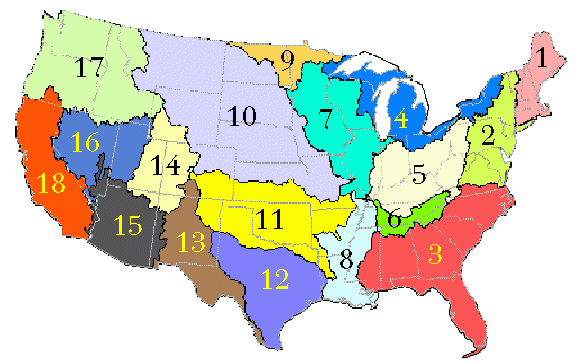
| P-ROUTE Flow Data for USGS Water Regions 1, 2, 3, 4 |
1.03 MB |
 |
| P-ROUTE Flow Data for USGS Water Regions 5, 6, 7, 8, 9 |
0.99 MB |
|
| P-ROUTE Flow Data for USGS Water Regions 10, 11, 12 |
1.14 MB |
|
| P-ROUTE Flow Data for USGS Water Regions 13, 14, 15, 16, 17, 18 |
1.12 MB |
|
|
Wonder which USGS Water Resources Region you're living in?
See the USGS Water Resources Region Map below.
Description and how to use flow data "catalog" information
in P-ROUTE is also available.
|
|